Gallarate Città dove vivere: “Produzione, Commercio e Mobilità”_Gallarate (VA) 10 marzo 2018

Incontro Produzione, Commercio e Mobilità nel quadro del ciclo di seminari organizzati a cura dell’Assessorato all’Urbanistica e Ambiente  del Comune di Gallarate (VA) in previsione della Città del Futuro da disegnare con la variante del PGT.

Giorgio Limonta del Laboratorio Urb&Com interviene sul tema specifico del rapporto tra urbanistica e commercio proponendo alcune riflessioni di carattere strategico portando come esempi le numerose esperienze di ricerca effettuate in questo campo da Urb&Com.

L’incontro si svolgerà presso la Sala degli Arazzi del museo Maga dalle ore 10:30 alle ore 13:30.

Programma della giornata

10:00-10:30 Registrazione partecipanti

10:30-12:00 Relazioni introduttive

Giorgio Limonta

Giovanna Fossa

Felix Guenther

Valerio Montieri

12:00-13:30 Tavola rotonda

con la partecipazione di: Fabio Lunghi, Claudio Mangano, Beatrice Biella, Marco Introini

Moderatore Andrea Ciotti

Locandina dell’evento


2nd INTENSSS-PA RLLs Network Workshop_Maribor_26 febbraio 2018

Il 26-27 febbraio 2018 si terrà a Maribor, presso l’hotel Hotel City Maribor il secondo INTENSSS-PA RLLs Network Workshop. Si tratta di un evento legato al 5th Project Meeting organizzato dall’Association of Slovenian Municipality, Energy Agency of Pomurje nell’ambito del progetto A Systematic Approach for Inspiring and Training Energy-Spatial-Socioeconomic Sustainability to Public Authorities (INTENSSS-PA), finanziato attraverso il programma quadro Horizon 2020.
Mario Paris interverrà in qualità di esperto nell’Afternoon Session (15.00-17.30) con un intervento intitolato “Towards a smart governance for regional infrastructures and services? Spatial Knowledge as support, tool and benchmark”.

Panel: Afternoon Session

Description: The objective of the afternoon session is to provide experience and expert knowledge on issues of priority for the majority of the RLLs. Considering the development stage of the project and the focus of the seven RLLs planning efforts, issues on Business Models for RLLs, Integration of Renewables on land-scape Architecture, Land Uses-Energy Productions Sites and Socio-economic developments, as well as on sustainability and performance aspects of LLs coordinated on regional/local level by public organizations have been identified of great importance.


Maggiori informazioni riguardo al progetto sono disponibili al sito ufficiale del progetto INTENSSS-PA.

A continuazione il programma dell’evento

Continua

RICS European Retail Conference_Milano_6 febbraio 2018

Il 6 febbraio 2018 (8.15-17:00) si terrà a Milano, presso l’hotel Melià l’annuale European Retail Conference dal titolo “The evolving retail experience: the changing customer demands”  organizzata da RICS in associazione con CNCC. A questo evento prenderanno parte Mario Paris e Giorgio Limonta, membri del Laboratorio Urb&Com.

Mario Paris interverrà in qualità di rappresentante nel panel coordinato da Adolfo Suarez (Lombardini22). Insieme a loro,  una serie di esperti che dibatteranno sul ruolo del commercio come elemento di rigenerazione urbana e driver di innovazione ed attrattività nella città e nel territorio:

Panel: More malls going green

Description: Sustainability is playing an increasingly important role when considering the design of new buildings. Discover what other factors that are being considered to ensure development schemes become more attractive to consumers.

Panelists:

Adolfo Suarez, Lombardini22

Romain Molho-Lavignie, Unibail-Rodamco

Leonardo Cavalli, One Works

Alan Muse, RICS

Mario Paris, Urb&Com Lab – Politecnico of Milano

Maggiori informazioni riguardo all’evento, ai temi trattati e alle modalità di partecipazione sono disponibili al sito ufficiale, del quale a continuazione riportiamo un estratto.

Continua

Seminario de Formación Doctoral “Producir conocimiento espacial”_Valladolid (E)_16-19 ottobre 2017

Seminario de Formación Doctoral “Producir conocimiento espacial”_Valladolid (E)_16-19 ottobre 2017

Nei giorni 16-19 ottobre a Valladolid avrà luogo il seminario dal titolo “Producir conocimiento espacial”, nell’ambito dei programmi di formazione offerti dalla scuola di dottorato dell’Università di Valladolid e del MS-CA European Joint Doctorate UrbanHist.  Le lezioni, le pratiche sul campo e le attività desk saranno guidate da Mario Paris, membro del laboratorio Urb&Com e del IUU-Instituto Universitario de Urbanistica de la UVa, invitato grazie ai fondi legati al bando “Ayudas para la estancia de investigadores de otras instituciones para la realizaciòn de actividades de formaciòn doctoral. Convocatoria única para el curso 2017-2018” promossa dall’Universidad de Valladolid. A continuazione si presenta il calendario delle attività ed il brief di presentazione disponibile anche sul sito dell’IUU.


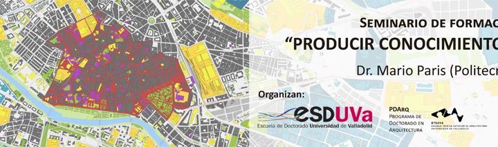
Durante los próximos días 16 a 19 de octubre, en la ETS de Arquitectura, el miembro del IUU y profesor en el Politecnico di Milano Mario Paris impartirá el seminario de formación doctoral “Producir conocimiento espacial”, enmarcado en la oferta de actividades formativas de la Escuela de Doctorado de la Universidad de Valladolid y más específicamente en el Programa de Doctorado en Arquitectura. El seminario se orienta a ayudar a los doctorandos a enfocar la lectura del territorio y a integrarla en sus trabajos de investigación, tomando contacto con las metodologías y herramientas más recientes e innovadoras en el campo de la cartografía y el análisis del territorio.

Como actividad formativa de la Escuela de Doctorado, el seminario está abierto a la participación de cualquier doctorando interesado en el tema, aunque se orienta muy especialmente a quienes desarrollan investigaciones doctorales en las que el factor espacial/territorial es determinante, como es el caso del Doctorado en Arquitectura o el Doctorado en Patrimonio Cultural y Natural: Historia, arte y territorio, estando asimismo prevista la participación de los doctorandos del EJD urbanHIST.

El programa previsto, que se desarrollará en la ETS de Arquitectura, es el siguiente:

Lunes 16 de octubre (Sala de Juntas):

10h00-10h30: Presentación del seminario

10h30-12h00: Sesión teórica 1

Producir conocimiento espacial: definición de un campo de trabajo (objetivos y desafíos)
Análisis espacial avanzado: herramientas para entender cómo reaccionan los territorios a diferentes escalas.

12h00-12h30: Descanso

12h30-14h00: Sesión teórica 2

Hacia una lectura del territorio compartida: los VGI y la plataforma Open Street Map.
La cartografía como soporte: experiencias recientes de lectura del territorio al servicio de la investigación y de procesos de toma de decisiones.

14h00-14h30: Debate

Martes 17 de octubre (Sala de informática):

11h30-13h30: Workshop. WP1: Presentación y metodología

Miércoles 18 de octubre (Sala de informática):

11h30-13h30: Workshop. WP2: Práctica de campo (alrededor de la ETS de Arquitectura)

17h30-19h30: Workshop. WP3: Restitución y organización de datos

Jueves 19 de octubre (Sala de informática/Sala de juntas):

17h30-18h30: Workshop. WP4: Interpretación

18h30-19h30: Mesa redonda final para discusión de resultados

Os adjuntamos a continuación un texto de presentación del seminario:

La producción de conocimiento espacial como soporte a los estudios territoriales: objetivos, métodos y desafíos

En su relectura del trabajo de H. Lefebvre, E. W. Soja (1996; p.47) pone en evidencia la necesidad de trabajar el espacio desde una perspectiva que cruza diferentes disciplinas, para que salga de los compartimentos estancos a los que lo reducen los diferentes enfoques sectoriales. “El espacio” —en sus palabras— “es demasiado importante para que se ocupen de ello las disciplinas como la geografía, la arquitectura, los estudios urbanos, etc. de forma específica o, peor aún, que se quede como relleno o como un fondo para los historiadores, los sociólogos marxistas o los que se dedican a las ciencias sociales. La espacialidad de la vida humana (…) influencia cada disciplina y cada discurso.”

A lo largo de la última década, distintas ramas del conocimiento dentro de los estudios territoriales (geografía, nuevas tecnologías, economía, ciencias sociales, etc.) han investigado las oportunidades basadas en lecturas alternativas del espacio. Entre ellas, la producción de “spatial knowledge” (Limonta & Paris, 2017; Dovey & Ristic, 2017) se configura como el resultado de un conjunto de prácticas, desarrolladas según las aspiraciones de F. Jameson (1992) que aspiraba a la creación de una cartografía cognitiva con el objetivo de describir el territorio contemporáneo de una forma más útil y eficaz respecto a las técnicas tradicionales. Se trata de introducir en la investigación de los materiales y de las practicas urbanas un enfoque procesual (Kitchin & al., 2012; Kitchin & al., 2009), técnicas digitales y lecturas performativas (Perkins, 2009) aprovechando de metodologías consolidadas en otras disciplinas. El resultado es la producción de mapas, diagramas y esquemas diferentes, donde el espacio es representado a través de la recombinación de información sectorial, modelos estadísticos y datos geográficos (De las Rivas & al., 2014). Este soporte representa una base eficaz para detectar fenómenos, así como para descubrir potenciales y límites de un espacio y se puede aplicar a distintas investigaciones, adaptando los productos a las necesidades subjetivas. Al mismo tiempo el trabajo sobre la dimensión espacial de los fenómenos socioeconómicos, de las practicas del habitar contemporáneos, y el intento de representar de una forma objetiva y trasmisible los impactos que tienen en el territorio puede considerarse una herramienta para promover la colaboración interdiscpilinar entre programas. Se trata de un ejercicio útil para crear un terreno común para el debate, el proceso de individuación de problemas y de toma de decisiones que los doctorandos —cada uno enfocando los temas desde su perfil especifico— pueden aplicar dentro de los distintos programas doctorales involucrados (en arquitectura, historia del urbanismo y geografía). Los resultados de la aplicación de la metodología propuesta pueden servir para crear atlas relacionados con los trabajos de los estudiantes del tercer ciclo y definir también de forma visual el campo de acción de cada uno y del programa en su conjunto, incluso de todos ellos a la vez.

El objetivo de este taller es proporcionar a los alumnos: (i) conceptos acerca de la producción de conocimiento espacial y sobre cómo esta cartografía alternativa puede ser una herramienta de trabajo útil dentro de los estudios territoriales; (ii) una innovadora metodología para relacionar fenómenos socio-económicos y sus impactos en el territorio gracias a bases de datos abiertas (open data) y sistemas de información geográfica (SIG) open source; (iii) conocimientos prácticos acerca del análisis espacial avanzado (advanced spatial analysis) y de las oportunidades proporcionadas en su relación con los VGI (Volunteer Geographic Information) y, de forma especial, con la plataforma OpenStreetMap.

Todo ello pretende estimular a los estudiantes a introducir en sus respectivas investigaciones una cartografía diferente, más precisa y más orientada a la lectura del potencial y de los caracteres del lugar y de los efectos espaciales de las trasformaciones socioeconómicas y tecnológicas (análisis). Al mismo tiempo, estas herramientas son más eficaces a la hora de proporcionar lecturas que abren nuevos escenarios y, de una forma “transductiva” (Lefebvre, 1968), vinculan lo real y lo posible (síntesis), combinando escalas diferentes e incluyendo también la dimensión del tiempo y del futuro (proyecto), por lo que resultan adecuadas para complementar los trabajos de los alumnos en sus enfoques específicos.

Bibliografía

De las Rivas, J.L., Paris, M. y Jiménz, M. (2014) ‘Creating figures: why re-imagining urban structure supports a regenerative urban mode’ en Architecture MPS – Online publication.
Dovey, K., Ristic, M. (2017) ‘Mapping urban assemblages: the production of spatial knowledge’ en Journal of Urbanism: International Research on Placemaking and Urban Sustainability, n. 10(1), pp. 15-28.
Jameson, F. (1992) The geopolitical aesthetic: cinema and space in the world system. Bloomington (IN, USA): Indiana University Press.
Kitchin, R., Perkins, C. y Dodge, M. (2012) ‘Unfolding mapping practices: a new epistemology for cartography’, en Transactions of the Institute of British Geographers, 1-17.
Kitchin, R., Perkins, C. y Dodge, M. (2009) ‘Thinking about maps’ en: Dodge, M., Kitchin, R. y Perkins, C., eds., (2009) Rethinking maps. Oxton (UK): Routledge.
Lefebvre, H. (1968) Le droit à la ville. Paris: Anthropos.
Limonta, G., Paris, M. (2017) ‘Riconoscere e monitorare la potenziale fragilità dei sistemi commerciali urbani: una proposta per la Regione Lombardia’ en: AA.VV., Atti della XIX Conferenza Nazionale SIU “Cambiamenti. Responsabilità e strumenti per l’urbanistica al servizio del paese”. Milano-Roma (I), Planum Publisher.
Pavia, R. (2002) Babele: la città della dispersione. Roma: Meltemi.
Perkins, C. (2009) ‘Performative and Embodied Mapping’ en: Kitchin, R., Thrift, N. (2009) International Encyclopedia of Human Geography. Amsterdam (NL): Elsevier.
Secchi, B. (1994) ‘Figure del rinnovo urbano’ en Casabella n. 614, pp. 16-17.
Soja, E.W. (1996) The third space: journeys to L.A. and other real-and imaginated places. Oxford (UK): Blackwell.


Per maggiori informazioni riguardo all’evento,  si consiglia la visita al sito ufficiale del seminario, al seguente link.

Programma


Continua

IV International Seminar City, Retail and Consumption_Lisbona (P)_12-15 settembre 2017

IV International Seminar City, Retail and Consumption_Lisbona (P)_12-15 settembre 2017

Nei giorni 12-15 settembre a Lisbona si terrà la VI edizione del seminario Internazional City, Retail and Consumption, da titolo “Retail, Consumption and the New forms of Urban Governance”.  Alcuni membri del laboratorio URB&COM parteciperanno alle attività programmate, presentando l’esito di ricerche recenti. 


Merc. 13 settembre – Asse II: The new entrepreneurial logic of retail and services and the challenges they pose to scientific research and urban policies, h. 11.00-12,45
TITOLO: “Mapping deadmalls landscape: how VGI support research and actions on abandoned retail heritage
AUTORI: Giorgio Limonta, Gabriele Cavoto, Mario Paris
ABSTRACT: “Over the last two decades, Italy experimented on one hand a deep transformation in retail sector, due to a process of deregulation, which stimulated the growing of retail chains, the attraction of foreign capitals and the modernization of retail networks, and, on the other hand, the impacts of the economic crisis, which affect consumption practices and users’ behaviours. The combination of these factors and the consequent evolution – in number, dimensions and formats – of retail poles (Brunetta & Morandi, 2009) generated a strong territorial competition for urban/metropolitan areas with a progressive market saturation that, amongst other effects, accelerates the obsolescence of older settlements.In U.S., similar trends caused a selective process for a number of big box stores and shopping malls, and in several cases, they result in the appearance of deadmalls and ghostboxes. Italy is on the first phase of this process, where the number of these “retail greyfields” is increasing and where scholars and public actors are becoming aware of their territorial presence that, due to their mass and landscape impacts represent a sort of landmarks of retail abandon (Cavoto, 2014). The group of Italian deadmalls is composed by an heterogeneous set of elements, where together with timeworn settlements, also recent structures appear, sometime unfinished or just partially completed. They all belong to an increasing stock but is difficult to provide reliable data at regional or national scale.

In recent times, several authors, described those new italian landscapes of economic desertification  (Turri, 2000; Cavoto, 2014; Inti, Cantaluppi, Persichino, 2014; Minelli, 2015). Unfortunately,  they provide just fragmentary descriptions and not interpretative readings of the phenomenon. One of the cause could be the lack of a shared knowledge, based on exhaustive information and institutional data. This deficit imposes a reflection about the role of alternative databases based on alternative sources in the research about retail dismantling and depletion of local economic systems.

The aim of this contribution is reflecting on the opportunities related with the involvement of Volunteered Geographic Information (VGI) on this issue (Goodchild, 2007), especially when related with the platform OpenStreetMap (OSM) and presenting an original methodology of spatial analysis and territorial monitoring. This approach, developed within the URB&COM Lab of Politecnico di Milano is an useful tool for the collection and the classification of data, and is especially effective for the stock of closed, abandoned or dismantled structures. The methodology allows to set up a shared geography of dismantled retail activities both in urban and suburban contexts, and has been the starting point for several recent research related with the monitoring of urban retail systems (Limonta and Paris, 2016)”.

Gio. 14 settembre – Asse II: The new entrepreneurial logic of retail and services and the challenges they pose to scientific research and urban policies, h. 09.00-11,45
TITOLO: “Trends, risks and opportunities in current luxury-driven transformations in cities
AUTORE: Mario Paris
ABSTRACT: “Historically, urban aristocracy and, after the industrial revolution, a growing upper-middle class based on bourgeois citizens have been reference targets for producers and retailers of luxury goods. For this reason, and luxury-consumption and its impacts on economy and customers’ behaviors have been fields largely explored by many different fields (as geography, philosophy, management, marketing and economics, psychology, architecture and tourism); all these contributions underlined its consolidate relationship with urban culture. This issue is even more evident considering that not only luxury market (for goods, real estate, services) but also luxury productions (art, artisanship, design, creative productions, etc.) belong to the urban domain. Despite this strong connection with the city, luxury has been largely ignored as a topic in urban studies and planning research; or worse, it has been discussed in rather ideological and mono-directional terms (“all about gentrification”). This pre-conceived attitude prevents the exploration of potentials and innovations related with this topic. This lack is particularly serious today, when luxury, as economic sector and as system of values, involves a set of practices that affect the spatial dimension and, therefore, influences the transformation of contemporary territories and the creations of specific lifestyles as well as it impacts on the everyday life of inhabitants and space users, although they are not luxury consumers.The aim of this contribution is presenting the outcomes of a research focused on the recent urban interventions developed by luxury stakeholders, and pointing out several specific features of their actions. Therefore, they exceed the simple retail or real estate approach, developing placemaking strategies and a role as urban agents following some recent trends (from exclusiveness to prestige, masstige, etc.). For this reason, operators and practitioners belonging to this sector show a renovate interest for values and characters of places, they focus on the provision of services and experiences and not only of goods, and they use urban design, art and culture as tools for their global branding. At the same time, their actions have different social, economic and spatial impacts on the city, and a focus on recent cases study points out risks and opportunities related with these operations. In some luxury-driven intervention, it emerges a reinforcement of differences and boundaries within the city, in other cases, inverse processes of opening -sometime temporarily – of gated spaces to the urban population. Sometimes, designed transformations acting as a catalyst for urbanity and regeneration, in others they emphasize processes of polarization. In the conclusions, several open questions about governances will be pointed out and about if (and how) these interventions can produce urban values and competitive advantages for their contexts, and not only economic benefits for developers involved”.

Inoltre durante l’evento “incontro con gli autori” di giovedì 14 (h. 16.00-18.00) verrà presentato il libro “Making Prestigious Places. How luxury influences the transformation of cities“, edito da Mario Paris e pubblicato da Routledge.


Per maggiori informazioni riguardo all’evento, all’organizzazione ed alla rete internazionale di ricercatori coinvolti, si consiglia la visita al sito ufficiale del seminario, al seguente link.

Programma


Continua

XXXII Congresso Geografico Italiano_Roma_7-10 giugno 2017

Dal 7 al 10 Giugno 2017 si svolgerà presso la Scuola di Lettere Filosofia Lingue dell’Università Roma Tre, Via Ostiense 234-236, 00146 (Roma), il XXXII Congresso geografico italiano, promosso dall’Associazione dei geografi italiani. Una delegazione del Laboratorio URB&COM parteciperà all’interno dello slot 2 della sessione S37 – Oltre la “new retail geography”: teorie, politiche e pratiche dei luoghi del commercio nella città / Beyond the “new retail geography”: theories, policies and practices of retail places in the city del 9 giugno presso l’aula Matassi (h. 14,30), coordinata da Libera D’Alessandro (Università di Napoli L’Orientale); Enrico Nicosia (Università di Macerata); Carmelo Porto (Università di Messina) con due paper presentati da Giorgio Limonta e Gabriele Cavoto e da Mario Paris e Giorgio Limonta.

Continua

Mappatura e monitoraggio delle dinamiche commerciali locali attraverso OpenStreetMap (OSM)_2016-2017

Attraverso l’attività di ricerca e consulenza tecnico-scientifica del Laboratorio URB&COM si persegue tra le altre la finalità di condividere il patrimonio conoscitivo realizzato con l’ulteriore obiettivo di mantenere aggiornato il dato geografico relativo alla distribuzione delle attività commerciali per monitorare l’evoluzione delle dinamiche locali ed in particolar modo il fenomeno della dismissione commerciale.

A partire dall’attività di ricerca intrapresa a supporto del Comune di Bergamo si è deciso di avvalersi delle potenzialità offerte dai Volunteered Geographic Information (VGI) (informazioni georeferenziate provenienti da progetti di collaborative mapping) per l’aggiornamento delle informazioni geografiche relative alle attività commerciali raccolte con il rilievo effettuato per l’ambito della Distretto Urbano de Commercio di Città Bassa. In particolare si è scelto di utilizzare OpenStreetMap (OSM) un progetto sorto nel 2004 con lo scopo di creare una mappa a livello mondiale costruita ed editabile direttamente dagli utenti, liberamente condivisa ed utilizzabile da parte di chiunque in licenza ODbL. Per fare questo è stato necessario definire una modalità di mappatura delle attività commerciali in grado di stabilire una relazione univoca tra la classificazione normativa delle attività del terziario commerciale e la tassonomia utilizzata in OSM. Questa procedura è stata definita anche grazie al confronto con i responsabili italiani del progetto OSM (in occasione dell’evento OSMIT “Wikipedia, mappe libere e musei” tenutosi a Milano il 20 e il 21 maggio 2016) che hanno validato la metodologia suggerendo migliorie e accorgimenti procedurali (link alla presentazione).

Questa attività verrà proposta in tutti i futuri progetti di ricerca del Laboratorio e vedrà un ulteriore sviluppo per l’ambito di Bergamo con la mappatura delle attività commerciali delle polarità distrettuali di “Città Alta”, “Borgo Palazzo” e “Borgo Santa Caterina” e con la mappatura delle attività del centro storico della città di Parma.

Timing: 2016 – in corso

Monitoraggio degli spazi commerciali sfitti attraverso OSM

Visualizza a schermo intero

Dettaglio per l’ambito del DUC del comune di Bergamo OSM

Visualizza a schermo intero